

 For the development and testing of process
models of stratigraphic development as well as the application
of these models to understanding heterogeneity in petroleum
and groundwater reservoirs, it is increasingly important to
obtain high-resolution, three-dimensional data from outcrops.
For the development and testing of process
models of stratigraphic development as well as the application
of these models to understanding heterogeneity in petroleum
and groundwater reservoirs, it is increasingly important to
obtain high-resolution, three-dimensional data from outcrops.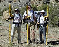 Digital data acquisition systems (e.g., differential GPS, laser-range
finder) have notably improved in usability and decreased in
cost in the last decade, and can significantly enhance quantitative
geologic mapping. There are many advantages of digital-data
collection. Each three-dimensional data point can be tagged
with multiple geological attributes (e.g., grain size, facies,
lithology, fossil type, stratigraphic surface, etc.). The digital
data can be quickly visualized and analyzed in three-dimensions.
The length scales of geometrical relationships defined by facies
or stratal boundaries can be easily quantified. Finally, quantitative
digital-field datasets can be directly incorporated in quantitative
stratigraphic or reservoir models.
Digital data acquisition systems (e.g., differential GPS, laser-range
finder) have notably improved in usability and decreased in
cost in the last decade, and can significantly enhance quantitative
geologic mapping. There are many advantages of digital-data
collection. Each three-dimensional data point can be tagged
with multiple geological attributes (e.g., grain size, facies,
lithology, fossil type, stratigraphic surface, etc.). The digital
data can be quickly visualized and analyzed in three-dimensions.
The length scales of geometrical relationships defined by facies
or stratal boundaries can be easily quantified. Finally, quantitative
digital-field datasets can be directly incorporated in quantitative
stratigraphic or reservoir models. The
data acquisition system includes realtime kinematic GPS receivers
(Trimble 4700 GPS receiver) and a total station that includes
laser distance measurements with or without surveying reflectors
(Trimble TTS-300 total station). With both of these systems,
relative positional accuracy is approximately 2-5 cm horizontally,
and 5-10 cm vertically. The absolute positional accuracy (i.e.,
in world map coordinates) is approximately 20 cm.
The
data acquisition system includes realtime kinematic GPS receivers
(Trimble 4700 GPS receiver) and a total station that includes
laser distance measurements with or without surveying reflectors
(Trimble TTS-300 total station). With both of these systems,
relative positional accuracy is approximately 2-5 cm horizontally,
and 5-10 cm vertically. The absolute positional accuracy (i.e.,
in world map coordinates) is approximately 20 cm.Data points are normally collected every 2 meters. Each three-dimensional data point that is collected is tagged with multiple geological attributes (e.g., lithofacies, lithology, stratigraphic-surface name, sedimentary structure, etc.).
 The
data is loaded in a modeling package (in our case PETREL). With
this package, the data are visualized, mapped and modeled in
3D.
The
data is loaded in a modeling package (in our case PETREL). With
this package, the data are visualized, mapped and modeled in
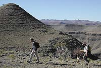
3D.The field areas that were digitally mapped are the terminal Proterozoic of the Nama Group, Namibia, and the Devonian of the Canning Basin, Australia.